Antarctica, ice melt and global sea level rise
Cold Environments Knowledge Booster

Sponsored by

Developed in partnership with


Course links: GCSE • IGCSE • A-level • IA-level • IB • National 5 • Leaving Cert • Higher Geography
Description
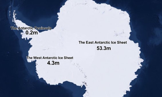
Antarctica contains 90% of the world's ice. If all this ice melted, global sea levels would rise by 58 metres! So as global air and ocean temperatures rise, it is important that we understand how Antarctica is changing. To investigate this, we team up with leading Antarctic researchers Dr David Small and Dr Bethan Davies. Through hands-on demonstrations, we explore:
- The fascinating makeup of Antarctica: a rocky continent covered by a dynamic system of ice sheets, ice shelves and ice streams,
- How these different types of ice respond to climate change and affect sea levels,
- What this means for future global sea level rise.
Acknowledgements
Written and developed by: David Small, Bethan Davies, Rob Parker, Harriet Ridley, Tim Parker, Emily Bilbie, Addy Pope, Katie Hall, David Morgan, Adrian Luckman
This video was supported with funding from NERC grant NE/T011963/1.
Thank you to Dr Adrian Luckman for making ice flow time lapse clips of Thwaites Glacier and Pine Island Glacier available for use in this video. These visualisations contain modified Copernicus Sentinel-1 data (2016-2019), processed by ESA.
Attributions
Ben Smith, Helen A. Fricker, Alex S. Gardner, Brooke Medley, et al. (2020) Pervasive ice sheet mass loss reflects competing ocean and atmosphere processes, Figure 3 is licensed from The American Association for the Advancement of Science.
Distant iceberg calves in Vest Fjord sound by jeo is licensed under CC-BY-4.0
Antarctic Bedrock video by NASA is in the public domain
Flow of Ice Across Antarctica video by NASA is in the public domain
Antarctic Land Ice Height Change video by NASA is in the public domain
Ocean Flows Under Pine Island Glacier video by NASA is in the public domain
Pine Island Glacier Ice Flows and Elevation Change video by NASA is in the public domain
Runaway Glaciers in West Antarctica video by NASA is in the public domain
Global and UK sea level rise visuals are licensed under the ESRI Master License Agreement and used with the permission of ESRI UK.


