Our Geographer of the Month is Daisy Woodley, a specialist risk consultant at AIR Worldwide. Daisy and her colleagues are helping society prepare for catastrophic events, from tsunamis and earthquakes to cybercrime and global pandemics. We spoke with Daisy about her career in geography, the geographical skills she uses daily, and how jobs like hers benefit people around the world.
New to Time for Geography? Sign up to join our mailing list.
"I think all the future decision-makers of the world should be geographers! We are very reliant on the weather and climate and we need to continue to study and learn its processes so we can continue to live on Earth in a healthy, productive way."
TFG: Hi Daisy and welcome to Time For Geography. Firstly, can you tell us why you think Geography is important?
Daisy: Other than it being the reason we are where we are today, I think all the future decision-makers of the world should be geographers! We are very reliant on the weather and climate and we need to continue to study and learn its processes so we can continue to live on Earth in a healthy, productive way. I believe that geography answers so many of life’s big questions and does it looking beautiful at the same time! You are discovering new things and the opportunity to learn just keeps on coming. Geography also has the power to end everything as we know it!
TFG: Indeed it does! That's part of why future geographers are so important. What was it that led you to study geography at university?
Daisy: I loved learning about geography at school, and travel is a big passion of mine. I realised that studying geography and travelling go hand in hand! I am also a very visual learner, so being able to see the geographical wonders I had learnt about in the classroom helped me process complex topics.
I studied physical geography at university and I focused on the more practical modules, specialising in geographical information systems and modelling, specifically flood and river modelling. I have never been much of an essay writer! I prefer to write reports based on practical work. The facilities at Exeter University are great and you can be involved in some amazing practical experiments and field trips. Much of the Exeter department focus is on climate change so naturally, most of my modelling tended to follow this direction.
TFG: Studying geography has led you to a very exciting career. Can you tell us more about the company you work for, AIR Worldwide?
Daisy: AIR Worldwide is a catastrophe modelling company. We build models to help companies understand their risk to all kinds of natural “perils”, such as earthquakes, hurricanes, tsunamis, wildfires or flooding. We then make these models into software for people and companies to use. For example, we could look at your home and use our models to work out the likelihood of damage from any given peril (earthquake, flooding, hurricane) and the potential cost of damage caused by the event. AIR also does the same thing for man-made perils, like cybercrime, terrorism, or disease pandemics, like COVID-19.
This video explains a little more about catastrophe modelling and the work we do:
TFG: Sounds fascinating! What's your role within AIR Worldwide?
Daisy: I work in our Client and Consulting Services Group. My team is responsible for making sure our clients know how to use the software and are up-to-date with new features. We also help them understand what the model is telling them. I also work on a diverse range of bespoke consultancy projects.
TFG: How do you use geography and geographical skills in your career?
Daisy: I use my knowledge from both school and university every day! From my understanding of earthquakes and flooding to my skills in environmental modelling. I also use my knowledge of climate change and its impacts to help model future risk.
TFG: What's the best thing about your job?
Daisy: I enjoy so many parts of my job it's difficult to pick one! The diversity of my day-to-day work is incredible. No day is the same and some of the projects I work on can be very exciting. If there has been a natural catastrophe it is all hands on deck to make sure we can inform clients of the potential damage from the event as fast as possible.
I also really like that I can help people. Whether it's explaining complex issues or resolving problems, every day I feel a sense of achievement. And I love the fact I get to work with maps! Like most geographers I love maps. On a day-to-day basis, I use my skills in ArcMap (a Geographical Information System) to help explain high-hazard areas and modelling results to clients.
Another aspect of what we do involves resilience-based projects, such as the ones we participate in for World Bank, where we help communities that might not have access to the information they need to plan and protect against hazards. I feel that in this way we can give something back that is not purely commercial.
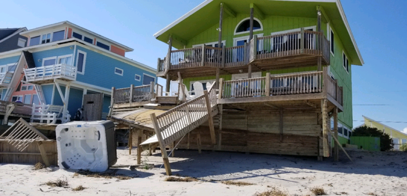
Storm surge damage to a wooden deck and concrete foundation in Surf City, North Carolina, caused by Hurricane Florence in 2018. (Source: AIR)
TFG: What is the most challenging aspect of your job?
Daisy: My work is incredibly dynamic and forever changing, which means every day I learn something new and must adapt. The industry is very fast-paced; when a natural disaster happens there is immediate pressure for our team to come up with a response on how much damage will occur and how much the repair costs may be. The insurance industry is a very old industry. We are on the brink of a new era and it is important to make sure we are on board with these changes and are dynamic enough to adapt.
TFG: How are new technologies changing your field?
Daisy: There is a big push towards new technologies in the insurance industry. One of the main opportunities we have is around ‘big data’ and the advances in AI (artificial intelligence) and supercomputers. Machine learning, a type of artificial intelligence, is increasing the amount of processing that could be done by a human—and advances are happening fast. Also, top-down views from satellites have made responding to events in real-time a possibility, leaving no area of the globe unexplored. The combination of satellites and AI will transform the way we report on event damage in the future. Meanwhile, supercomputers mean that climate change models that used to take months to run can now run in just a few days! This means we can incorporate new scientific findings into our models much faster.
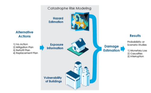
A simple framework of catastrophe modelling. Frameworks like this are used to evaluate the impact on lives, the built environment, and the resilience of a community, and help make plans to protect them. (Source: AIR)
TFG: What was the most eye-opening thing about studying geography at university?
Daisy: Once you get to university level, you realise that what you are studying is the backbone of many major decisions that will impact the future of our world. Of particular importance at the moment is climate change. Also, when you study a subject at university there is a real enthusiasm from everyone to learn new things.
TFG: Are there skills and abilities important to what you do now that you learnt outside the classroom?
Daisy: Being innovative! This isn't a skill that you're necessarily taught at school, but it's really important. It allows you to see opportunities, or to come up with a completely new set of tools or models to solve a problem or reach a goal.
Teamwork is another skill learnt outside the classroom. Teamwork is a skill that you will find invaluable in the workplace. Most of the work I do daily is done within a team.
TFG: How is AIR Worldwide playing an important role in addressing major challenges facing the world?
Daisy: There are so many points I could discuss here! I'll focus on two topics: climate change and resilience.
We are very involved in addressing climate change issues. All AIR models are developed to reflect the current climate—accounting for the changes that have already occurred—but AIR’s Director of Climate Change Research is responsible for identifying the research we must undertake to ensure that our catastrophe models continue to reflect the current climate as it changes.
We are also addressing major issues in the resilience sector. AIR has a Global Resilience practice that has worked on many consulting projects. One such project involved creating earthquake-resistant desks for a school in Bhutan.
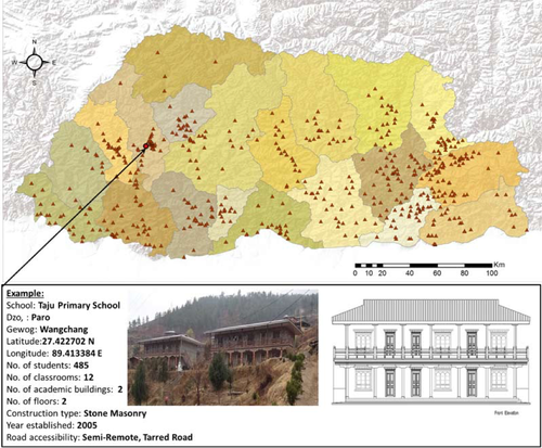
Location, construction type, and other exposure data were gathered for 550 schools in Bhutan as part of a project to create earthquake-resistant decks for schools in the country. (Source: AIR).
TFG: What advice do you have for young people reading this article who are interested in pursuing a geographical career?
Daisy: Work hard and find out what interests you. If you are working on something you love, it shouldn’t feel like work. Once you understand what you enjoy, go to a good university that specialises in the areas you are interested in. Make sure you look at the choice of modules on offer and make sure it is the type of geography you enjoy and about which you are passionate. Once you are surrounded by like-minded people, you can engage and develop your understanding.
Never be scared to ask questions!
Travel the world because it helps to make the things you have learnt about in the classroom come to life. Keep up to date with blogs and societies that interest you. Here at AIR, we produce a blog, which can keep you informed on the new and exciting things we are involved in. The catastrophe modelling world is developing very fast and is a very exciting industry.
Does this sound interesting to you? Learn more about catastrophe modelling and risk assessment at AIR Worldwide.
